

Pathfinder
Editor, Senior Moderator
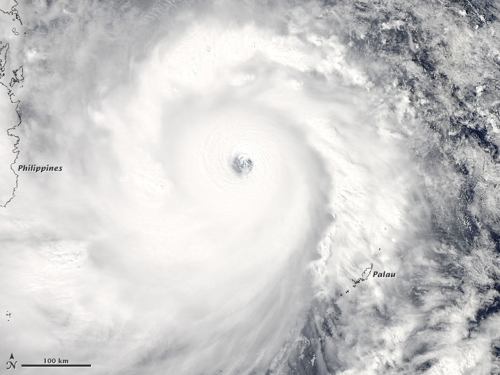
acquired November 7, 2013
The Moderate Resolution Imaging Spectroradiometer (MODIS) on NASA?s Aqua satellite acquired this natural color image of Super Typhoon Haiyan as it moved west toward the coast of the Philippines. The image was acquired at 1:25 p.m. local time (4:25 Universal Time) on November 7, 2013.
http://earthobservatory.nasa.gov/NaturalHazards/view.php?id=82341&eocn=home&eoci=nh
------------------------------------------------------------------------------------------
Super typhoon makes landfall in the Philippines
</SECTION><SECTION id=module-position-MuRoNB7lT0I class="storytopbar-bucket story-byline-module">Doyle Rice, USA TODAY 5:11 p.m. EST November 7, 2013
</SECTION>
It is one of the most intense storms in world history.
Super Typhoon Haiyan made landfall early Friday morning in Guiuan, a small city in Samar province in the eastern Philippines.
Thousands of people evacuated villages in the central Philippines on Thursday as one of the strongest typhoons in world history took aim the region, which was devastated by an earthquake last month.
Haiyan had intensified and accelerated as it moved closer to the country with sustained winds of 195 mph and ferocious gusts of 235 mph, according to the U.S. Navy's Joint Typhoon Warning Center.
No Atlantic or eastern Pacific hurricane has ever been stronger than Haiyan (typhoons are the same type of storms as hurricanes).
About 10 million people live on the central Philippine islands and are most at risk from a direct strike from Haiyan.
More...
http://www.usatoday.com/story/news/world/2013/11/07/philippines-typhoon/3465779/
Last edited:


