• FluTrackers.com Inc. does not provide medical advice. Information on this web site is collected from various internet resources, and the FluTrackers board of directors makes no warranty to the safety, efficacy, correctness or completeness of the information posted on this site by any author or poster. The information collated here is for instructional and/or discussion purposes only and is NOT intended to diagnose or treat any disease, illness, or other medical condition. Every individual reader or poster should seek advice from their personal physician/healthcare practitioner before considering or using any interventions that are discussed on this website. By continuing to access this website you agree to consult your personal physican before using any interventions posted on this website, and you agree to hold harmless FluTrackers.com Inc., the board of directors, the members, and all authors and posters for any effects from use of any medication, supplement, vitamin or other substance, device, intervention, etc. mentioned in posts on this website, or other internet venues referenced in posts on this website.
  • We are not asking for any donations. Do not donate to any entity who says they are raising funds for us.

Tropical storm Debby soaks Florida

Pathfinder

Editor, Senior Moderator
Tropical Depression could form from disturbance
622+tropical+disturance.jpg


PinPoint Weather Staff

The area of low pressure in the southern Gulf, just east of the Yucatan Peninsula, has now been given a 70 percent chance of development. The low is becoming better defined and a tropical depression may form in the next day or so. Models are still in disagreement as to where the system will eventually go. Some models are predicting it to move toward Florida, while others have it heading north for awhile, before sending it toward Texas.
...
http://www.wwltv.com/weather/Tropical-Update--Weather-Forecast-69340202.html

-----------------------------------------------------------------------------------

two_atl.gif

<TABLE><TBODY><TR><TD width=565 align=right>GIS data: .shp</TD></TR></TBODY></TABLE>

ZCZC MIATWOAT ALLTTAA00 KNHC DDHHMM TROPICAL WEATHER OUTLOOK NWS NATIONAL HURRICANE CENTER MIAMI FL200 PM EDT FRI JUN 22 2012 FOR THE NORTH ATLANTIC...CARIBBEAN SEA AND THE GULF OF MEXICO...

THE NATIONAL HURRICANE CENTER HAS ISSUED THE FINAL ADVISORY ON POST-TROPICAL CYCLONE CHRIS...LOCATED ABOUT 335 MILES EAST-SOUTHEAST OF CAPE RACE NEWFOUNDLAND.1. SATELLITE IMAGERY AND SURFACE OBSERVATIONS INDICATE THAT THE CIRCULATION ASSOCIATED WITH THE BROAD SURFACE LOW LOCATED JUST NORTH OF THE YUCATAN PENINSULA HAS BECOME A LITTLE BETTER DEFINED OVER THE PAST FEW HOURS. WHILE THE SHOWER AND THUNDERSTORM ACTIVITY HAS CHANGED LITTLE IN ORGANIZATION...ENVIRONMENTAL CONDITIONS APPEAR CONDUCIVE FOR A TROPICAL DEPRESSION TO FORM. THIS SYSTEM HASA HIGH CHANCE...70 PERCENT...OF BECOMING A TROPICAL CYCLONE DURING THE NEXT 48 HOURS AS IT BEGINS TO MOVE SLOWLY NORTHWARD. INTERESTSALONG THE UNITED STATES GULF COAST SHOULD MONITOR THE PROGRESS OFTHIS DISTURBANCE THROUGH THE WEEKEND. HEAVY RAINS AND LOCALIZED FLOODING ARE POSSIBLE ACROSS THE YUCATAN PENINSULA...WESTERN CUBA...AND SOUTHERN FLORIDA THROUGH SATURDAY. ELSEWHERE...TROPICAL CYCLONE FORMATION IS NOT EXPECTED DURING THE NEXT 48 HOURS.
http://www.nhc.noaa.gov/gtwo_atl.shtml
 
Re: Gulf of Mexico - Tropical Depression could form from disturbance

Re: Gulf of Mexico - Tropical Depression could form from disturbance

Murphy Oil Evacuates Personnel From Gulf Of Mexico As Storm Approaches

Published June 22, 2012
Dow Jones Newswires

Murphy Oil Corp. (MUR) is evacuating all non-essential personnel from its Gulf of Mexico operations as the liklihood of a tropical storm in the region increases, the company said Friday.

Evacuating non-essential employees is generally the first step in preparing for the onset of a tropical cyclone. BP PLC (BP, BP.LN), Chevron Corp. (CVX), Royal Dutch Shell PLC (RDSA, RDSB, RDSA.LN, RDSB.LN) and other oil and gas companies operate oil rigs and platforms staffed with thousands of workers in the Gulf.

In the Gulf of Mexico, Murphy operates the Thunder Hawk, Medusa and Frontrunner platforms.

"We are monitoring the storm closely," Murphy spokesman Barry Jeffery said. "There has been no impact on operations."


Read more: http://www.foxbusiness.com/news/201...ulf-mexico-as-storm-approaches/#ixzz1yZgGW3fb
 
Re: Gulf of Mexico - Tropical Depression could form from disturbance

Re: Gulf of Mexico - Tropical Depression could form from disturbance

Gulf of Mexico Storm Threat Sparks Rig Evacuations

By Brian K. Sullivan and Lynn Doan on June 22, 2012


Gulf of Mexico energy platforms began evacuations and shutdowns as a weather system off the Yucatan Peninsula threatened to grow into a tropical storm over the weekend.
...
Computer models can?t give a clear indication of where the system may go because there isn?t a storm yet, Dennis Feltgen, a spokesman for the hurricane center in Miami, said by telephone earlier today.

?They?re all over the place,? he said. ?The models are going to look like a squashed spider, so I wouldn?t put any stock in it.?
...
?That is definitely a system that has to be paid attention to,? said Tom Kines, an expert senior meteorologist at AccuWeather Inc. in State College, Pennsylvania. ?I think the odds are pretty high that it will be a named storm before the weekend is over.?
...
The chance of the storm growing into a hurricane before going ashore sometime next week are slim at the moment, said Jim Rouiller, senior energy meteorologist at Planalytics Inc. in Berwyn, Pennsylvania. While the waters of the Gulf are warm enough to spark a system, ?the heat content doesn?t favor rapid intensification,? he said.
...

Full text:
http://www.businessweek.com/news/2012-06-22/gulf-of-mexico-storm-threat-sparks-rig-evacuations
 
Re: Gulf of Mexico - Tropical Depression could form from disturbance

Re: Gulf of Mexico - Tropical Depression could form from disturbance

TROPICAL WEATHER OUTLOOK
NWS NATIONAL HURRICANE CENTER MIAMI FL
800 AM EDT SAT JUN 23 2012

FOR THE NORTH ATLANTIC...CARIBBEAN SEA AND THE GULF OF MEXICO...

1. THE CENTER OF CIRCULATION OF THE BROAD AREA OF LOW PRESSURE OVER THE
GULF OF MEXICO APPEARS TO BE BECOMING BETTER DEFINED ABOUT 275
MILES SOUTH-SOUTHEAST OF THE MOUTH OF THE MISSISSIPPI RIVER. IN
ADDITION...SHOWERS AND THUNDERSTORMS HAVE BEEN INCREASING OVER THE
EASTERN GULF OF MEXICO...AND A NOAA BUOY LOCATED ABOUT 130 MILES
EAST-NORTHEAST OF THE CENTER HAS PRODUCED TROPICAL-STORM-FORCE
WINDS WITHIN THE PAST COUPLE OF HOURS. A TROPICAL DEPRESSION...OR
MORE LIKELY A TROPICAL STORM...COULD FORM LATER TODAY OR TONIGHT IF
THE DEVELOPMENT TREND CONTINUES. THIS SYSTEM HAS A HIGH CHANCE...
90 PERCENT...OF BECOMING A TROPICAL CYCLONE AS IT MOVES SLOWLY
NORTHWARD DURING THE NEXT 48 HOURS.

TROPICAL STORM WATCHES OR WARNINGS COULD BE REQUIRED FOR A PORTION
OF THE NORTHERN GULF COAST OVER THE WEEKEND...AND INTERESTS IN THIS
AREA SHOULD CONTINUE TO MONITOR THE PROGRESS OF THIS LOW. HEAVY
RAINS AND LOCALIZED FLOODING ARE POSSIBLE ACROSS THE YUCATAN
PENINSULA...WESTERN CUBA...AND MUCH OF FLORIDA OVER THE NEXT DAY OR
SO. AN AIR FORCE RESERVE RECONNAISSANCE AIRCRAFT IS SCHEDULED TO
INVESTIGATE THE SYSTEM THIS AFTERNOON.

http://www.nhc.noaa.gov/gtwo_atl.shtml
 
Re: Tropical storm Debby forms in the Gulf of Mexico

Re: Tropical storm Debby forms in the Gulf of Mexico

Tropical Storm Debby disrupts Gulf oil, gas production

Updated 20m ago

MIAMI (AP) ? Tropical Storm Debby formed in the Gulf of Mexico on Saturday, interfering with oil and gas production and putting officials on alert for flooding and strong winds from Texas to Florida.
...
While the storm's track is far from certain, the National Hurricane Center has Debby skirting the Louisiana coast and heading west toward Texas. However, some forecasts have the storm moving east toward Florida.
...
It was the first time four tropical storms have been recorded before July 1 during the Atlantic hurricane season since record keeping began in 1851.
...
The government reported that nine production platforms and one drilling rig were evacuated. The suspended crude production amounts to about 2 percent of U.S production and about 0.1 percent of global production. The reduced production is not expected to impact oil prices unless the storm strengthens and forces more production platforms to close.

A tropical storm warning was issued for part of the southeast Louisiana coast. Officials there have been monitoring the weather closely for the last several days. Some low-lying areas close to the coast flood easily in rough weather.
...
A tornado touched down in Collier County in southwest Florida and forecasters warned other twisters were possible.

Several homes were damaged and tree limbs were down, The Naples Daily News reported.

Full text:
http://www.usatoday.com/weather/storms/story/2012-06-23/tropical-storm-debby/55783248/1?csp=34news
 
Re: Tropical storm Debby forms in the Gulf of Mexico

Re: Tropical storm Debby forms in the Gulf of Mexico

Florida -

Storm damage reported in East Naples, related to Tropical Storm Debby - PHOTOS

By Naples Daily News staff report
Naples Daily News
Posted June 23, 2012 at 5:21 p.m., updated June 23, 2012 at 10:02 p.m.

EAST NAPLES ?An East Naples neighborhood scrambled to patch roofs and clean up debris Saturday night from a wind storm related to Tropical Storm Debby, which formed in the evening in the Gulf of Mexico.

Initial reports to authorities of a tornado touching down near Rattlesnake Hammock Road and U.S. 41 East shortly before 4 p.m. are as yet unconfirmed, said <STYLE>a.inline_topic:hover { background-color: #EAEAEA;}</STYLE>Dan Summers, director of the Collier County Bureau of Emergency Services.

Instead, emergency officials labeled what occurred in East Naples as a downburst.

No injuries from the storm were reported, however strong winds primarily off of Catalina Drive damaged about 12 homes. Downed trees also destroyed two cars at an apartment complex at 4300 Gulfstream Drive.

A tornado warning was issued for Collier County immediately following the
initial reports of wind damage, but was lifted later Saturday evening just as Debby formed in the Gulf of Mexico.

More...
http://www.naplesnews.com/news/2012/jun/23/storm-damage-reported-east-naples/?partner=popular
 
Re: Tropical storm Debby forms in the Gulf of Mexico

Re: Tropical storm Debby forms in the Gulf of Mexico

Tropical Storm DEBBY Public Advisory

000
WTNT34 KNHC 240249
TCPAT4

BULLETIN
TROPICAL STORM DEBBY ADVISORY NUMBER 2
NWS NATIONAL HURRICANE CENTER MIAMI FL AL042012
1000 PM CDT SAT JUN 23 2012

...DEBBY REMAINS STATIONARY OVER THE CENTRAL GULF OF MEXICO...
...HEAVY SQUALLS AFFECTING PORTIONS OF WEST-CENTRAL AND
SOUTHWESTERN FLORIDA...


SUMMARY OF 1000 PM CDT...0300 UTC...INFORMATION
-----------------------------------------------
LOCATION...26.3N 87.5W
ABOUT 215 MI...350 KM SSE OF THE MOUTH OF THE MISSISSIPPI RIVER
MAXIMUM SUSTAINED WINDS...50 MPH...85 KM/H
PRESENT MOVEMENT...STATIONARY
MINIMUM CENTRAL PRESSURE...998 MB...29.47 INCHES


WATCHES AND WARNINGS
--------------------
CHANGES WITH THIS ADVISORY...

NONE.

SUMMARY OF WATCHES AND WARNINGS IN EFFECT...

A TROPICAL STORM WARNING IS IN EFFECT FOR...
* THE COAST OF LOUISIANA FROM THE MOUTH OF THE PEARL RIVER WESTWARD
TO MORGAN CITY...NOT INCLUDING THE CITY OF NEW ORLEANS OR LAKE
PONTCHARTRAIN

A TROPICAL STORM WARNING MEANS THAT TROPICAL STORM CONDITIONS ARE
EXPECTED SOMEWHERE WITHIN THE WARNING AREA WITHIN 36 HOURS.

FOR STORM INFORMATION SPECIFIC TO YOUR AREA IN THE UNITED
STATES...INCLUDING POSSIBLE INLAND WATCHES AND WARNINGS...PLEASE
MONITOR PRODUCTS ISSUED BY YOUR LOCAL NATIONAL WEATHER SERVICE
FORECAST OFFICE. FOR STORM INFORMATION SPECIFIC TO YOUR AREA OUTSIDE
THE UNITED STATES...PLEASE MONITOR PRODUCTS ISSUED BY YOUR NATIONAL
METEOROLOGICAL SERVICE.


DISCUSSION AND 48-HOUR OUTLOOK
------------------------------
AT 1000 PM CDT...0300 UTC...THE CENTER OF TROPICAL STORM DEBBY WAS
LOCATED NEAR LATITUDE 26.3 NORTH...LONGITUDE 87.5 WEST. DEBBY HAS
BEEN NEARLY STATIONARY THIS EVENING...AND LITTLE MOVEMENT IS
EXPECTED THROUGH SUNDAY MORNING. A SLOW NORTHWARD MOTION IS
FORECAST TO BEGIN BY SUNDAY AFTERNOON...FOLLOWED BY A GRADUAL
WESTWARD TURN SUNDAY NIGHT OR MONDAY MORNING. ON THE FORECAST
TRACK...THE CENTER OF DEBBY WILL BE MOVING OVER THE NORTHERN GULF
OF MEXICO DURING THE NEXT FEW DAYS.

MAXIMUM SUSTAINED WINDS ARE NEAR 50 MPH...85 KM/H...WITH HIGHER
GUSTS. THESE WINDS ARE OCCURRING WELL EAST OF THE CENTER OF
CIRCULATION. SOME STRENGTHENING IS FORECAST DURING THE NEXT 48
HOURS...AND DEBBY COULD BE NEAR HURRICANE STRENGTH BY MONDAY NIGHT.

TROPICAL-STORM-FORCE WINDS EXTEND OUTWARD UP TO 175 MILES...280 KM..
MAINLY NORTHEAST AND EAST OF THE CENTER.

THE ESTIMATED MINIMUM CENTRAL PRESSURE BASED ON NEARBY SHIP AND BUOY
REPORTS IS 998 MB...29.47 INCHES.


HAZARDS AFFECTING LAND
----------------------
WIND...TROPICAL STORM CONDITIONS ARE EXPECTED TO FIRST REACH THE
COAST WITHIN THE WARNING AREA BY SUNDAY NIGHT...MAKING OUTSIDE
PREPARATIONS DIFFICULT OR DANGEROUS.

STORM SURGE...THE COMBINATION OF A STORM SURGE AND THE TIDE WILL
CAUSE NORMALLY DRY AREAS NEAR THE COAST TO BE FLOODED BY
RISING WATERS. THE WATER COULD REACH THE FOLLOWING DEPTHS ABOVE
GROUND IF THE PEAK SURGE OCCURS AT THE TIME OF HIGH TIDE...

MISSISSIPPI AND SOUTHEASTERN LOUISIANA...1 TO 3 FT

THE DEEPEST WATER WILL OCCUR ALONG THE IMMEDIATE COAST IN AREAS OF
ONSHORE FLOW. SURGE-RELATED FLOODING DEPENDS ON THE RELATIVE
TIMING OF THE SURGE AND THE TIDAL CYCLE...AND CAN VARY GREATLY OVER
SHORT DISTANCES. FOR INFORMATION SPECIFIC TO YOUR AREA...PLEASE
SEE PRODUCTS ISSUED BY YOUR LOCAL NATIONAL WEATHER SERVICE OFFICE.

RAINFALL...DEBBY IS EXPECTED TO PRODUCE RAIN ACCUMULATIONS OF 3 TO 6
INCHES ALONG THE GULF COAST FROM SOUTHERN LOUISIANA TO THE FLORIDA
PANHANDLE...WITH POSSIBLE ISOLATED MAXIMUM AMOUNTS OF 10 INCHES.
ADDITIONAL RAINS OF 1 TO 3 INCHES WITH ISOLATED AMOUNTS UP TO 5
INCHES WILL BE POSSIBLE ACROSS PORTIONS OF THE WESTERN FLORIDA
PENINSULA.

TORNADOES...ISOLATED TORNADOES ARE POSSIBLE OVER PORTIONS OF THE
WEST-CENTRAL AND SOUTHWESTERN FLORIDA PENINSULA TONIGHT AND SUNDAY.


NEXT ADVISORY
-------------
NEXT INTERMEDIATE ADVISORY...100 AM CDT.
NEXT COMPLETE ADVISORY...400 AM CDT.

$$
FORECASTER STEWART/LANDSEA

http://www.nhc.noaa.gov/text/refresh/MIATCPAT4+shtml/240249.shtml

Tropical Storm Force Wind Speed Probabilities - 120 Hours
Select a Future Forecast Time Below:
0 12 24 36 48 60 72 84 96 108 120 hours Loop


Click image to zoom in ? Download GIS data: 0.1 degree .shp 0.5 degree .shp


Click Here for a Printer Friendly Graphic

Coastal Watches/Warnings and 5-Day Forecast Cone for Storm Center

Click image to zoom in ? Download GIS data
Other images: 5-Day track on ? 3-Day track on ? 3-Day track off ? Interactive<SUP>New!</SUP>


Click Here for a Printer Friendly Graphic
Note: If a storm is expected to dissipate within 5 days, its track will be shorter

http://www.nhc.noaa.gov/refresh/graphics_at4+shtml/024737.shtml?5-daynl#contents
 
Re: Tropical storm Debby forms in the Gulf of Mexico

Re: Tropical storm Debby forms in the Gulf of Mexico

Tropical Storm DEBBY Public Advisory

000
WTNT34 KNHC 241218
TCPAT4

BULLETIN
TROPICAL STORM DEBBY SPECIAL ADVISORY NUMBER 4...CORRECTED
NWS NATIONAL HURRICANE CENTER MIAMI FL AL042012
700 AM CDT SUN JUN 24 2012

CORRECTED TO MODIFY SURGE HAZARD STATEMENT...

...TROPICAL STORM WARNINGS ISSUED FOR A PORTION OF THE FLORIDA AND
ALABAMA GULF COAST...

SUMMARY OF 700 AM CDT...1200 UTC...INFORMATION
----------------------------------------------
LOCATION...27.5N 87.0W
ABOUT 170 MI...270 KM SE OF THE MOUTH OF THE MISSISSIPPI RIVER
ABOUT 195 MI...315 KM SW OF APALACHICOLA FLORIDA
MAXIMUM SUSTAINED WINDS...60 MPH...95 KM/H
PRESENT MOVEMENT...N OR 360 DEGREES AT 2 MPH...4 KM/H
MINIMUM CENTRAL PRESSURE...994 MB...29.35 INCHES


WATCHES AND WARNINGS
--------------------
CHANGES WITH THIS ADVISORY...

A TROPICAL STORM WARNING HAS BEEN ISSUED FROM THE MISSISSIPPI
ALABAMA BORDER EASTWARD TO OCHLOCKONEE RIVER FLORIDA.

SUMMARY OF WATCHES AND WARNINGS IN EFFECT...

A TROPICAL STORM WARNING IS IN EFFECT FOR...
* THE COAST OF LOUISIANA FROM THE MOUTH OF THE PEARL RIVER WESTWARD
TO MORGAN CITY...NOT INCLUDING THE CITY OF NEW ORLEANS OR LAKE
PONTCHARTRAIN
* THE MISSISSIPPI ALABAMA BORDER EASTWARD TO OCHLOCKONEE RIVER
FLORIDA.

A TROPICAL STORM WARNING MEANS THAT TROPICAL STORM CONDITIONS ARE
EXPECTED SOMEWHERE WITHIN THE WARNING AREA WITHIN 36 HOURS.

FOR STORM INFORMATION SPECIFIC TO YOUR AREA...INCLUDING POSSIBLE
INLAND WATCHES AND WARNINGS...PLEASE MONITOR PRODUCTS ISSUED BY
YOUR LOCAL NATIONAL WEATHER SERVICE FORECAST OFFICE.

DISCUSSION AND 48-HOUR OUTLOOK
------------------------------
AT 700 AM CDT...1200 UTC...THE CENTER OF TROPICAL STORM DEBBY WAS
LOCATED NEAR LATITUDE 27.5 NORTH...LONGITUDE 87.0 WEST. DEBBY IS
MOVING TOWARD THE NORTH NEAR 2 MPH...4 KM/H. THIS MOTION IS
EXPECTED TO CONTINUE TODAY...FOLLOWED BY A GRADUAL WESTWARD TURN
TONIGHT OR MONDAY MORNING. ON THE FORECAST TRACK...THE CENTER OF
DEBBY WILL BE MOVING OVER THE NORTHERN GULF OF MEXICO DURING THE
NEXT FEW DAYS.

MAXIMUM SUSTAINED WINDS ARE NEAR 60 MPH...95 KM/H...WITH HIGHER
GUSTS. SOME SLIGHT STRENGTHENING IS POSSIBLE DURING THE NEXT 48
HOURS.

TROPICAL STORM FORCE WINDS EXTEND OUTWARD UP TO 200 MILES...325 KM
FROM THE CENTER TO THE NORTHEAST OF THE CENTER. BALD POINT IN THE
FLORIDA BIG BEND RECENTLY REPORTED SUSTAINED WINDS OF 37 MPH...60
KM/H WITH GUSTS TO 43 MPH...69 KM/H.

LATEST MINIMUM CENTRAL PRESSURE REPORTED BY A RECONNAISSANCE PLANE
WAS 994 MB...29.35 INCHES.


HAZARDS AFFECTING LAND
----------------------
WIND...TROPICAL STORM CONDITIONS ARE ALREADY NEAR OR OVER PORTIONS
OF THE NORTHEAST GULF COAST AND ARE EXPECTED TO REACH THE REMAINDER
OF THE WARNING AREA BY TONIGHT...MAKING OUTSIDE PREPARATIONS
DIFFICULT OR DANGEROUS.

STORM SURGE...THE COMBINATION OF A STORM SURGE AND THE TIDE WILL
CAUSE NORMALLY DRY AREAS NEAR THE COAST TO BE FLOODED BY
RISING WATERS. THE WATER COULD REACH THE FOLLOWING DEPTHS ABOVE
GROUND IF THE PEAK SURGE OCCURS AT THE TIME OF HIGH TIDE...

APALACHEE BAY...3 TO 5 FT
SOUTHEASTERN LOUISIANA EASTWARD TO APALACHICOLA...2 TO 4 FT

THE DEEPEST WATER WILL OCCUR ALONG THE IMMEDIATE COAST IN AREAS OF
ONSHORE FLOW. SURGE-RELATED FLOODING DEPENDS ON THE RELATIVE
TIMING OF THE SURGE AND THE TIDAL CYCLE...AND CAN VARY GREATLY OVER
SHORT DISTANCES. FOR INFORMATION SPECIFIC TO YOUR AREA...PLEASE
SEE PRODUCTS ISSUED BY YOUR LOCAL NATIONAL WEATHER SERVICE OFFICE.

RAINFALL...DEBBY IS EXPECTED TO PRODUCE RAIN ACCUMULATIONS OF 3 TO 6
INCHES ALONG THE GULF COAST FROM SOUTHERN LOUISIANA TO THE FLORIDA
PANHANDLE...WITH POSSIBLE ISOLATED MAXIMUM AMOUNTS OF 10 INCHES.
ADDITIONAL RAINS OF 1 TO 3 INCHES WITH ISOLATED AMOUNTS UP TO 5
INCHES WILL BE POSSIBLE ACROSS PORTIONS OF THE WESTERN FLORIDA
PENINSULA.

TORNADOES...ISOLATED TORNADOES ARE POSSIBLE OVER PORTIONS OF THE
WEST-CENTRAL AND SOUTHWESTERN FLORIDA PENINSULA TODAY.


NEXT ADVISORY
-------------
NEXT COMPLETE ADVISORY...1000 AM CDT.

$$
FORECASTER AVILA

http://www.nhc.noaa.gov/text/refresh/MIATCPAT4+shtml/241218.shtml

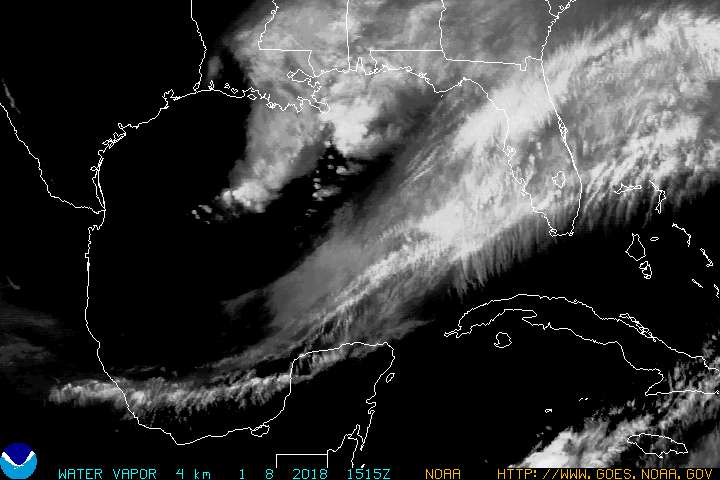
GULFWV.JPG

http://www.goes.noaa.gov/GIFS/GULFWV.JPG
 
Re: Tropical storm Debby forms in the Gulf of Mexico

Re: Tropical storm Debby forms in the Gulf of Mexico

1 killed in Florida by tornado spurred by Tropical Storm Debby

<!--endclickprintinclude--><!--startclickprintexclude--><!--no partner-->By the CNN Wire Staff
updated 6:54 PM EDT, Sun June 24, 2012


(CNN) -- The outer bands of Tropical Storm Debby lashed Florida on Sunday, spawning two apparent tornadoes in the central part of the state that killed one woman, a county spokeswoman said.

Gloria Rybinski, emergency operations spokeswoman for Highland County, said the twisters destroyed four homes in the southern end of the county and damaged others.

The woman was found dead in a home in Venus, located in the middle of the state roughly between Port St. Lucie and Sarasota, Rybinski said. In addition, a child in one of the affected homes was injured and transported to a hospital for treatment.

The slowly moving center of Debby remains in the Gulf of Mexico, though it's already pounding the region with torrential rain in addition to the perilous winds.
...
Fire and rescue personnel in nearby Clearwater responded to 30 calls in an hour, as of 6 p.m. Sunday, to help people stranded in their cars due to the flooding or needing urgent medical help, the city's public safety spokeswoman Elizabeth Watts said. Beach areas were "basically underwater," as were many side streets and at least two major thoroughfares -- U.S. Highway 19 and Gulf to Bay Boulevard.
...

Full text:
http://www.cnn.com/2012/06/24/us/tropical-weather/index.html
 
Re: Tropical storm Debby forms in the Gulf of Mexico

Re: Tropical storm Debby forms in the Gulf of Mexico

Tropical Storm Debby
<IFRAME height=315 src="http://www.youtube.com/embed/EcBhXsvvWHw" frameBorder=0 width=560 allowfullscreen></IFRAME>
Published on Jun 24, 2012 by ParsAreOk

Effects of Debby

Taken 6/24/12 at approx. 13:15 EST from 5th floor balcony at Palm Beach Montecito in downtown West Palm Beach. Video shows storm footage of high winds/rain and possible F1 meso (TBD by the NWS). Numerous tree limbs down; tops of trees sheared; large trees uprooted. Large aluminum vehicle entry gates ripped from hinges and street signs twisted and bent within 1 block radius.

http://www.youtube.com/watch?v=EcBhXsvvWHw

-----------------------------------------------------------
[*HOME VIDEO*] Tropical Storm Debby on Bayshore Ave. in Tampa!
<IFRAME height=360 src="http://www.youtube.com/embed/koKTntSmzXQ" frameBorder=0 width=480 allowfullscreen></IFRAME>
Published on Jun 24, 2012 by AdamKappel

http://www.youtube.com/watch?v=koKTntSmzXQ
 
Re: Tropical storm Debby forms in the Gulf of Mexico

Re: Tropical storm Debby forms in the Gulf of Mexico

Florida

LIVE BLOG: Tropical Storm Debby
http://www.baynews9.com/content/new...icles/bn9/2012/6/23/live_blog_tropical_s.html

6:45 p.m.
@JonathanYbor:
Bayshore Blvd. completely submerged

AwL9Q8bCEAArIBJ.jpg

http://twitter.com/JonathanYbor/status/217014199602253824/photo/1


Car completely submerged at Belcher Rd. and 142nd St. in ‪<S>#</S>Largo‬ -- <S>#</S>flwx MORE on http://BN9.com : pic.twitter.com/JNDDivgL


http://twitter.com/MicahGrimesBN9/status/217009343713910785/photo/1

Tampa Rd and Alt 19, in Palm Harbor. <S>@</S>BN9 <S>@</S>bn9weather pic.twitter.com/gR1RlY1O


http://twitter.com/GinaFit/status/217009072870932481/photo/1
 
Re: Tropical storm Debby forms in the Gulf of Mexico

Re: Tropical storm Debby forms in the Gulf of Mexico

Threat from Debby decreases for La.

Updated: Jun 24, 2012 7:58 PM CDT<NOSCRIPT orgfontsize="10.8px"></NOSCRIPT><!--END wnDate-->
Written by: Wire and Staff Reports

NEW ORLEANS (AP) - Forecasters dropped storm warnings for southeastern Louisiana Sunday afternoon and said the threat from Tropical Storm Debby had decreased.

National Hurricane Center forecasters backed away from an earlier projection that Debby might strike southeast Louisiana as a Category 1 hurricane. Instead they said they didn't expect it to turn west from its northward path that has it aimed at Florida and Alabama.

The morning forecast for a Louisiana strike prompted Louisiana officials to declare a state of emergency out of precaution. Louisiana officials did not order any evacuations but moved sandbags and other flood defenses into place.
...
http://www.fox8live.com/story/18867185/tropical-storm-wa

-------------------------------------------------------------

storm_04.gif


https://my.sfwmd.gov/sfwmd/common/images/weather/plots/storm_04.gif
 
Re: Tropical storm Debby forms in the Gulf of Mexico

Re: Tropical storm Debby forms in the Gulf of Mexico

000
WTNT34 KNHC 252051
TCPAT4

BULLETIN
TROPICAL STORM DEBBY ADVISORY NUMBER 10
NWS NATIONAL HURRICANE CENTER MIAMI FL AL042012
400 PM CDT MON JUN 25 2012

...FLOOD THREAT TO CONTINUE FOR THE NEXT DAY OR TWO...


SUMMARY OF 400 PM CDT...2100 UTC...INFORMATION
----------------------------------------------
LOCATION...29.3N 85.1W
ABOUT 30 MI...45 KM SSW OF APALACHICOLA FLORIDA
MAXIMUM SUSTAINED WINDS...45 MPH...75 KM/H
PRESENT MOVEMENT...NE OR 40 DEGREES AT 5 MPH...7 KM/H
MINIMUM CENTRAL PRESSURE...993 MB...29.32 INCHES


WATCHES AND WARNINGS
--------------------
CHANGES WITH THIS ADVISORY...

NONE.

SUMMARY OF WATCHES AND WARNINGS IN EFFECT...

A TROPICAL STORM WARNING IS IN EFFECT FOR...
* THE FLORIDA GULF COAST FROM DESTIN TO ENGLEWOOD

FOR STORM INFORMATION SPECIFIC TO YOUR AREA...INCLUDING POSSIBLE
INLAND WATCHES AND WARNINGS...PLEASE MONITOR PRODUCTS ISSUED BY
YOUR LOCAL NATIONAL WEATHER SERVICE FORECAST OFFICE.


DISCUSSION AND 48-HOUR OUTLOOK
------------------------------
DEBBY IS A LARGE TROPICAL CYCLONE...WITH STRONG WINDS AND HEAVY
RAINS OCCURRING AT LARGE DISTANCES FROM THE CENTER.

AT 400 PM CDT...2100 UTC...THE CENTER OF TROPICAL STORM DEBBY WAS
LOCATED NEAR LATITUDE 29.3 NORTH...LONGITUDE 85.1 WEST. DEBBY IS
MOVING TOWARD THE NORTHEAST NEAR 5 MPH...7 KM/H. A SLOW MOTION
TOWARD THE NORTHEAST OR EAST-NORTHEAST IS EXPECTED DURING THE NEXT
COUPLE OF DAYS.

MAXIMUM SUSTAINED WINDS REMAIN NEAR 45 MPH...75 KM/H...WITH HIGHER
GUSTS. LITTLE CHANGE IN STRENGTH IS FORECAST DURING THE NEXT 48
HOURS.

TROPICAL-STORM-FORCE WINDS EXTEND OUTWARD UP TO 230 MILES...370 KM
MAINLY TO THE SOUTHEAST OF THE CENTER.

THE ESTIMATED MINIMUM CENTRAL PRESSURE IS 993 MB...29.32 INCHES.


HAZARDS AFFECTING LAND
----------------------
WIND...TROPICAL STORM CONDITIONS WILL CONTINUE OVER PORTIONS OF
THE FLORIDA GULF COAST TONIGHT AND TUESDAY.

STORM SURGE...ALTHOUGH DEBBY HAS WEAKENED SOME TODAY...COASTAL
FLOODING IS NOT YET DIMINISHING. THE COMBINATION OF A STORM SURGE
AND THE TIDE WILL CAUSE NORMALLY DRY AREAS NEAR THE COAST TO BE
FLOODED BY RISING WATERS. THE WATER COULD REACH THE FOLLOWING
DEPTHS ABOVE GROUND AT THE TIME OF THE NEXT HIGH TIDE THIS
EVENING...

APALACHEE BAY TO WACCASASSA BAY...3 TO 5 FT
FLORIDA WEST COAST SOUTH OF WACCASASSA BAY...1 TO 3 FT

THE DEEPEST WATER WILL OCCUR ALONG THE IMMEDIATE COAST IN AREAS OF
ONSHORE FLOW. SURGE-RELATED FLOODING DEPENDS ON THE RELATIVE
TIMING OF THE SURGE AND THE TIDAL CYCLE...AND CAN VARY GREATLY OVER
SHORT DISTANCES. FOR INFORMATION SPECIFIC TO YOUR AREA...PLEASE
SEE PRODUCTS ISSUED BY YOUR LOCAL NATIONAL WEATHER SERVICE OFFICE.

RAINFALL...DEBBY IS EXPECTED TO PRODUCE THE FOLLOWING ADDITIONAL
RAIN ACCUMULATIONS OVER THE NEXT COUPLE OF DAYS...6 TO 12 INCHES
ACROSS NORTHERN FLORIDA...4 TO 8 INCHES ACROSS CENTRAL FLORIDA AND
EXTREME SOUTHEASTERN GEORGIA...AND 3 TO 5 INCHES IN SOUTH FLORIDA
AND EXTREME SOUTHEASTERN SOUTH CAROLINA. ISOLATED STORM TOTAL
AMOUNTS OF 25 INCHES ARE POSSIBLE IN NORTH FLORIDA.

TORNADOES...A FEW TORNADOES ARE POSSIBLE TODAY ACROSS THE EASTERN
FLORIDA PANHANDLE...THE FLORIDA PENINSULA...AND SOUTHERN GEORGIA.


NEXT ADVISORY
-------------
NEXT INTERMEDIATE ADVISORY...700 PM CDT.
NEXT COMPLETE ADVISORY...1000 PM CDT.

$$
FORECASTER KIMBERLAIN/FRANKLIN

http://www.nhc.noaa.gov/text/refresh/MIATCPAT4+shtml/252051.shtml
 
Tropical storm Debby soaks Florida

Evacuations in Florida as Debby soaks state

By the CNN Wire Staff

updated 12:38 PM EDT, Tue June 26, 2012
...
Authorities in Pasco County issued a mandatory evacuation order Tuesday for some 2,000 homes along the Cotee River because of flooding.

Officials were traveling by boat and car to get the word out, said county spokesman Eric Keaton. Water is standing in some homes as of Tuesday, he said. Another area river, the Anclote, was above flood stage on Tuesday, and water is not expected to recede for two days. A total of 106 homes in the county are reported damaged, Keaton said.

In Columbia County, west of Jacksonville, authorities were preparing for the Suwannee River to rise 22 feet in one day.

The river was 55 feet at White Springs, Florida, on Monday, said Harvey Campbell, spokesman for Columbia County emergency operations. On Tuesday, the prediction is for the river to rise past flood stage -- 77 feet.

"We have significant flooding problems," Campbell said. "I have people who don't remember in their lifetime the kind of rain we had overnight."
...
More than 20 inches of rain have fallen across northern Florida, particularly in areas just south of Tallahassee, according to the National Weather Service. Panacea, Florida, saw 20.63 inches in 24 hours; Sanborn, Florida, received 16.26 inches; and Saint Marks, Florida, received 20.96 inches over the past 48 hours, according to the weather agency.

The National Weather Service in Tallahassee issued a civil emergency message telling residents to stay home and off the roads.

In Sopchoppy, Florida, authorities rescued 57 people from homes surrounded by rising water, said Keith Blackmar of the Wakulla County Sheriff's Office.
...
Flooding was seen as far south as Fort Myers, Florida, where the Caloosahatchee River overflowed its banks into the downtown area. CNN iReporter Alex Butler, who is also a reporter at CNN affiliate WFTX, said normally there is a wall separating the land from the river, but the wall was underwater Tuesday.
...
The widespread damage resulted not only from Debby's slow movement, but also from the storm's size -- tropical storm-force winds of at least 39 mph extended outward up to 205 miles from its center. On Monday, rain bands from Debby passed over Hilton Head Island, South Carolina.

Full text:
http://www.cnn.com/2012/06/26/us/tropical-weather/index.html
 
Re: Tropical storm Debby soaks Florida

<TABLE style="BORDER-COLLAPSE: collapse" id=MainContent_MainContent_AlertGridView class=grid cellSpacing=0><TBODY><TR><TH style="WIDTH: 12%" class=ascending scope=col>Region</TH><TH style="WIDTH: 12%" scope=col>County</TH><TH style="WIDTH: 12%" scope=col>Highway</TH><TH style="WIDTH: 12%" scope=col>Entity</TH><TH style="WIDTH: 12%" scope=col>Severity</TH><TH style="WIDTH: 40%" scope=col>Message</TH></TR><TR><TD class=ascending>Panhandle</TD><TD>Santa Rosa</TD><TD></TD><TD></TD><TD>intermediate</TD><TD>Pensacola Beach: Due to weather, J. Earle Bowden Way/CR-399 is closed between Pensacola Beach and Navarre. Seek alternate route. </TD></TR><TR class=even><TD class=ascending>Panhandle</TD><TD></TD><TD></TD><TD></TD><TD>intermediate</TD><TD>Due to Tropical Storm Debby, expect strong winds, heavy rains, and possible local road closures.</TD></TR><TR><TD class=ascending>Panhandle</TD><TD>Wakulla</TD><TD></TD><TD></TD><TD>intermediate</TD><TD>Panacea: On US-98 East at Bottoms Rd. the roadway is closed due to flooding. Use alternate routes.</TD></TR><TR class=even><TD class=ascending>Panhandle</TD><TD>Wakulla</TD><TD></TD><TD></TD><TD>minor</TD><TD>Sopchoppy: SR-377 at SR-375 and Syfrette Creek Rd, the road is closed due to flooding. Use alternate Route.</TD></TR><TR><TD class=ascending>Panhandle</TD><TD>Santa Rosa</TD><TD></TD><TD></TD><TD>minor</TD><TD>Santa Rosa: There is a brush fire near I-10 West Bound beyond MM 23. Plase use caution in the area. </TD></TR><TR class=even><TD class=ascending>Panhandle</TD><TD>Wakulla</TD><TD></TD><TD></TD><TD>intermediate</TD><TD>Sopchoppy: On US-319 and Allen Green Rd, the roadway is closed due to water. Use alternate route.</TD></TR><TR><TD class=ascending>Panhandle</TD><TD>Franklin</TD><TD></TD><TD></TD><TD>intermediate</TD><TD>Alligator Point: Alligator Drive at SR-30, the roadway is closed due to weather conditions.</TD></TR><TR class=even><TD class=ascending>Panhandle</TD><TD>Franklin</TD><TD></TD><TD></TD><TD>intermediate</TD><TD>Eastpoint: Island Drive at US-98, the St. George Island Bridge is closed to commercial traffic due to high winds. </TD></TR><TR><TD class=ascending>Panhandle</TD><TD>Wakulla</TD><TD></TD><TD></TD><TD>minor</TD><TD>Crawfordville: SR-30 eastbound is CLOSED at Wildwood Drive and CR-367 at CR-365/Spring Creek HWY, due to flooding. Use alternate routes. </TD></TR></TBODY></TABLE>
Data Last Updated: Tuesday, June 26, 2012 1:57 PM

-----------------------------------------------------------------

<TABLE style="BORDER-COLLAPSE: collapse" id=MainContent_MainContent_AlertGridView class=grid cellSpacing=0><TBODY><TR><TH style="WIDTH: 12%" class=ascending scope=col>Region</TH><TH style="WIDTH: 12%" scope=col>County</TH><TH style="WIDTH: 12%" scope=col>Highway</TH><TH style="WIDTH: 12%" scope=col>Entity</TH><TH style="WIDTH: 12%" scope=col>Severity</TH><TH style="WIDTH: 40%" scope=col>Message</TH></TR><TR><TD class=ascending>Northeast</TD><TD>Nassau</TD><TD></TD><TD></TD><TD>intermediate</TD><TD>Nassau County: US-1 is CLOSED between Sikes Road and Charis Road due to flooding. </TD></TR><TR class=even><TD class=ascending>Northeast</TD><TD>Baker</TD><TD></TD><TD></TD><TD>intermediate</TD><TD>Macclenny: Due to flooding, SR-121 is CLOSED at Steel Bridge Road. </TD></TR><TR><TD class=ascending>Northeast</TD><TD>Baker</TD><TD></TD><TD></TD><TD>major</TD><TD>Near Lake City: I-10 eastbound is CLOSED from I-75 to US-41 and I-10 westbound is CLOSED from US-90 to I-75 due to flooding. Use caution and seek an alternate route.</TD></TR><TR class=even><TD class=ascending>Northeast</TD><TD>Columbia</TD><TD></TD><TD></TD><TD>major</TD><TD>Near Lake City: I-10 eastbound is CLOSED from I-75 to US-41 and I-10 westbound is CLOSED from US-90 to I-75 due to flooding. Use caution and seek an alternate route.</TD></TR><TR><TD class=ascending>Northeast</TD><TD>Suwannee</TD><TD></TD><TD></TD><TD>intermediate</TD><TD>Suwannee County: Due to flooding, US-90 is CLOSED in both directions at CR-137 in Wellborn and within the city limits of Live Oak. </TD></TR><TR class=even><TD class=ascending>Northeast</TD><TD>Columbia</TD><TD></TD><TD></TD><TD>intermediate</TD><TD>Lake City: Due to flooding, SR-247 is CLOSED from US-90 to Bascom Norris Road. </TD></TR><TR><TD class=ascending>Northeast</TD><TD>Levy</TD><TD></TD><TD></TD><TD>minor</TD><TD>Cedar Key: SR-24 is closed between 2nd and 4th Streets due to flooding. Use caution and seek alternate routes.</TD></TR><TR class=even><TD class=ascending>Northeast</TD><TD></TD><TD></TD><TD></TD><TD>major</TD><TD>Due to Tropical Storm Debby, expect strong winds, heavy rains, and possible local road closures.</TD></TR></TBODY></TABLE>
Data Last Updated: Tuesday, June 26, 2012 1:59 PM

--------------------------------------------------------------
<TABLE style="BORDER-COLLAPSE: collapse" id=MainContent_MainContent_AlertGridView class=grid cellSpacing=0><TBODY><TR><TD class=ascending>Central</TD><TD>Marion</TD><TD></TD><TD></TD><TD>major</TD><TD>Flooding in Marion County has closed CR-314 at the Sharpe Ferry Bridge. Motorists should seek an alternate route.</TD></TR></TBODY></TABLE>
-----------------------------------------------------------------

<TABLE style="BORDER-COLLAPSE: collapse" id=MainContent_MainContent_AlertGridView class=grid cellSpacing=0><TBODY><TR><TD class=ascending>Tampa Bay</TD><TD>Pasco</TD><TD></TD><TD></TD><TD>major</TD><TD>Pasco- SR-54 is closed in both directions from Madison st. to Mitchell Ranch rd. Use alternate routes.</TD></TR><TR class=even><TD class=ascending>Tampa Bay</TD><TD></TD><TD></TD><TD></TD><TD>major</TD><TD>The Sunshine Skyway Bridge is closed in both directions due to a high wind advisory. Please use other routes.</TD></TR></TBODY></TABLE>

.../
http://www.fl511.com/

---------------------------------------------------------------------
Shelters Locator

Locate a nearby emergency shelter by zip code and address. This tool may be used for planning and during an evacuation order.

http://floridaevacuates.com/locator
 
Re: Tropical storm Debby soaks Florida

Don't drive your vehicle into waist-high water unless it's a boat. This car is abandoned at Swann and Bayshore. <S>#</S>Tampa pic.twitter.com/yQ44it97


powered by
turkey-icon.png
Photobucket
9:17 AM - 26 Jun

http://twitter.com/abcactionnews/status/217652884555300864/photo/1


Pasco deputies tell me everyone is complying with evacuation of Seven Springs in Trinity, FL. Water 5 feet at deepest. pic.twitter.com/zewFYGKw


powered by
turkey-icon.png
Photobucket
9:37 AM - 26 Jun 12via Twitter for Android

http://twitter.com/ashleygTV/status/217657749595635712/photo/1
 
Re: Tropical storm Debby soaks Florida

Tropical Storm DEBBY Public Advisory

000
WTNT34 KNHC 262058
TCPAT4

BULLETIN
TROPICAL STORM DEBBY ADVISORY NUMBER 14
NWS NATIONAL HURRICANE CENTER MIAMI FL AL042012
500 PM EDT TUE JUN 26 2012

...DEBBY MAKES LANDFALL NEAR STEINHATCHEE...COASTAL AND INLAND
FLOODING THREATS REMAIN...


SUMMARY OF 500 PM EDT...2100 UTC...INFORMATION
----------------------------------------------
LOCATION...29.5N 83.4W
ABOUT 35 MI...55 KM NNW OF CEDAR KEY FLORIDA
MAXIMUM SUSTAINED WINDS...40 MPH...65 KM/H
PRESENT MOVEMENT...ENE OR 70 DEGREES AT 6 MPH...9 KM/H
MINIMUM CENTRAL PRESSURE...995 MB...29.38 INCHES


WATCHES AND WARNINGS
--------------------
CHANGES WITH THIS ADVISORY...

THE TROPICAL STORM WARNING IN THE FLORIDA PANHANDLE AND FLORIDA BIG
BEND FROM MEXICO BEACH TO WEST OF STEINHATCHEE HAS BEEN
DISCONTINUED.

SUMMARY OF WATCHES AND WARNINGS IN EFFECT...

A TROPICAL STORM WARNING IS IN EFFECT FOR...
* THE FLORIDA GULF COAST FROM STEINHATCHEE TO ENGLEWOOD

FOR STORM INFORMATION SPECIFIC TO YOUR AREA...PLEASE MONITOR
PRODUCTS ISSUED BY YOUR LOCAL NATIONAL WEATHER SERVICE FORECAST
OFFICE.


DISCUSSION AND 48-HOUR OUTLOOK
------------------------------
NATIONAL WEATHER SERVICE DOPPLER RADAR DATA INDICATE THAT DEBBY HAS
MADE LANDFALL NEAR STEINHATCHEE FLORIDA.

AT 500 PM EDT...2100 UTC...THE CENTER OF TROPICAL STORM DEBBY WAS
LOCATED ON THE COAST NEAR LATITUDE 29.5 NORTH...LONGITUDE 83.4 WEST.
DEBBY IS MOVING TOWARD THE EAST-NORTHEAST NEAR 6 MPH...9 KM/H.
DEBBY HAS BEEN MOVING SLIGHTLY FASTER TOWARD THE EAST-NORTHEAST
NEAR 6 MPH...9 KM/H. AN EASTWARD OR EAST-NORTHEASTWARD MOTION WITH
SOME FURTHER INCREASE IN FORWARD SPEED IS EXPECTED DURING THE NEXT
COUPLE OF DAYS.

MAXIMUM SUSTAINED WINDS REMAIN NEAR 40 MPH...65 KM/H...WITH HIGHER
GUSTS. DEBBY IS EXPECTED TO WEAKEN TO A TROPICAL DEPRESSION
TONIGHT.

TROPICAL-STORM-FORCE WINDS EXTEND OUTWARD UP TO 175 MILES...280
KM...MAINLY TO THE SOUTHEAST OF THE CENTER.

THE ESTIMATED MINIMUM CENTRAL PRESSURE IS 995 MB...29.38 INCHES.


HAZARDS AFFECTING LAND
----------------------
WIND...TROPICAL STORM CONDITIONS WILL CONTINUE OVER PORTIONS OF
THE FLORIDA GULF COAST THROUGH THIS EVENING.

STORM SURGE...EVEN THOUGH DEBBY CONTINUES TO SLOWLY WEAKEN...COASTAL
FLOODING WILL CONTINUE DURING THE NEXT DAY OR TWO DUE TO PERSISTENT
ONSHORE WINDS. THE COMBINATION OF A STORM SURGE AND THE TIDE WILL
CAUSE AREAS NEAR THE COAST TO BE FLOODED BY RISING WATERS DURING THE
NEXT HIGH TIDE THIS EVENING...WITH LEVELS SIMILAR TO THOSE THAT
OCCURRED ON MONDAY. THE WATER COULD REACH THE FOLLOWING DEPTHS
ABOVE GROUND...

APALACHEE BAY AND THE NATURE COAST...2 TO 4 FT
SOUTH OF THE NATURE COAST INCLUDING TAMPA BAY...1 TO 3 FT

THE DEEPEST WATER WILL OCCUR ALONG THE IMMEDIATE COAST IN AREAS OF
ONSHORE FLOW. SURGE-RELATED FLOODING DEPENDS ON THE RELATIVE
TIMING OF THE SURGE AND THE TIDAL CYCLE...AND CAN VARY GREATLY OVER
SHORT DISTANCES. FOR INFORMATION SPECIFIC TO YOUR AREA...PLEASE
SEE PRODUCTS ISSUED BY YOUR LOCAL NATIONAL WEATHER SERVICE OFFICE.

RAINFALL...DEBBY IS EXPECTED TO PRODUCE ADDITIONAL RAIN
ACCUMULATIONS OF 4 TO 8 INCHES OVER NORTHERN FLORIDA AND EXTREME
SOUTHEASTERN GEORGIA THROUGH WEDNESDAY EVENING...WITH ISOLATED
RAINFALL TOTALS AS HIGH AS 10 INCHES. ISOLATED STORM TOTAL AMOUNTS
OF 25 INCHES ARE POSSIBLE IN NORTHERN FLORIDA.

TORNADOES...ISOLATED TORNADOES ARE POSSIBLE ACROSS THE FLORIDA
PENINSULA TONIGHT.


NEXT ADVISORY
-------------
NEXT INTERMEDIATE ADVISORY...800 PM EDT.
NEXT COMPLETE ADVISORY...1100 PM EDT.

$$
FORECASTER KIMBERLAIN/FRANKLIN
http://www.nhc.noaa.gov/text/refresh/MIATCPAT4+shtml/262058.shtml
 
Re: Tropical storm Debby soaks Florida

Florida cities face flooding as Tropical Storm Debby weakens

Published June 27, 2012

Associated Press

ST. GEORGE ISLAND, Fla. ? Debby was expected to head out into the Atlantic on Wednesday, but forecasters warn that the weakened storm still posed a flooding and tornado threat even if it doesn't pack the same punch.

The National Hurricane Center downgraded Debby from a tropical storm to a tropical depression Tuesday night as it slogged across northern Florida toward the Atlantic coast. Debby's maximum sustained winds early Wednesday were near 35 mph.

But forecasters said a combination of storm surge and tide could bring flooding to coastal areas that have already been drenched by the storm that sat virtually motionless in the Gulf of Mexico for several days.

There was already major flooding at Black Creek, as well as several other rivers in the Jacksonville region, National Weather Service meteorologist Angie Enyedi said. She said tornadoes could form to the east and the southeast of the storm.

The hurricane center said early Wednesday that Debby was 25 miles southeast of St. Augustine, Fla., and moving east-northeast at about 10 mph. The storm was expected to head out to sea later in the day.

But many in Debby's path were still recovering from flooding that damaged homes, washed out roads, opened up sinkholes and closed a section of Interstate 10 -- the state's main east-west highway.

Read more: http://www.foxnews.com/weather/2012...-debby-weakens/?test=latestnews#ixzz1z0VVhxAg

-------------------------------------------------------------------------------------

rb-l.jpg


http://www.ssd.noaa.gov/goes/east/eaus/rb-l.jpg

http://www.nhc.noaa.gov/satellite.shtml
 
Back
Top Bottom